Wild Goose link
G’day,
Oct 18th, 2015. After visiting Reynolds Flora Reserve we drove south with the intention of seeing some of the scenic attractions that the Wongan Hills district has on offer. First stop was Dingo Rock located 26 kms east of the town. Dingo Rock is a large granite outcropping taking up an area of 63 hectares and is similar to thousands of other large granite outcroppings that are scattered throughout Western Australia. The rock is surrounded by vegetation that is full of flowers but we were a few weeks too late to see the best of them. The rock has a magnificent example of a gnamma hole measuring two metres deep by about one metre in diameter. Some idiotic do-gooders have filled the hole in with rocks to protect YOU from falling in (there's a sign confirming just that). There are tens of thousands of gnamma holes scattered about the state- are the do-gooders going to fill them all in I wonder?
img-2422 Bottlebrush, Dingo Rock
img-2423 Dingo Rock
img-2424 Gnamma Hole filled in for your safety!
img-2426 Dingo Rock is surrounded by wheat fields
img-2428
Dingo Rock
Large granite outcroppings often have beautiful and intricately carved granite boulders scattered about the surface.
img-2429 Dingo Rock
img-2431 Dingo Rock
(Onion exfoliation and wind + rain erosion)
After leaving Dingo Rock we drove in to town and booked in to the caravan park for the night . Wongan Hills is a prosperous and modern country town supporting a population of 800. The town is a major centre providing services to the surrounding wheat farms. The town takes its name from the hills 12 kms north west of town. The hills are a scenic attraction and that is where we spent part of the following day.
Oct 19th. We headed west to Wongan Hills and initially drove up a very steep hill (sign said no caravans but I can't read) to the scenic lookout on top of Mount O'Brien.
img-2434 Wongan Hills surrounded by wheat
img-2435 Bottlebrush
img-2436 Bottlebrush
img-2437 Wheat fields
img-2438 Bottlebrush + European Honey Bee
img-2441 Scenic Lookout
img-2442 Mount O'Brien from afar
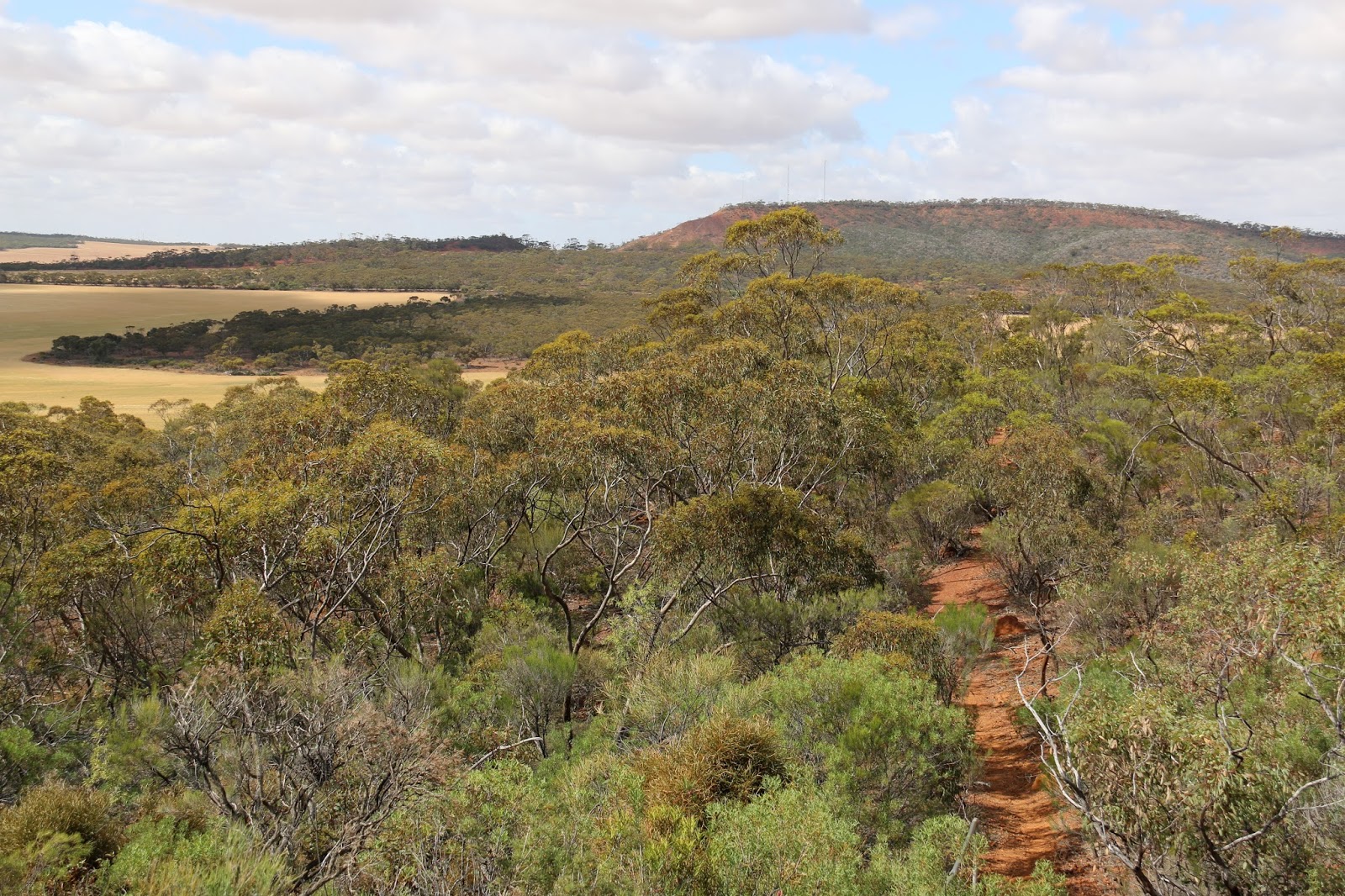
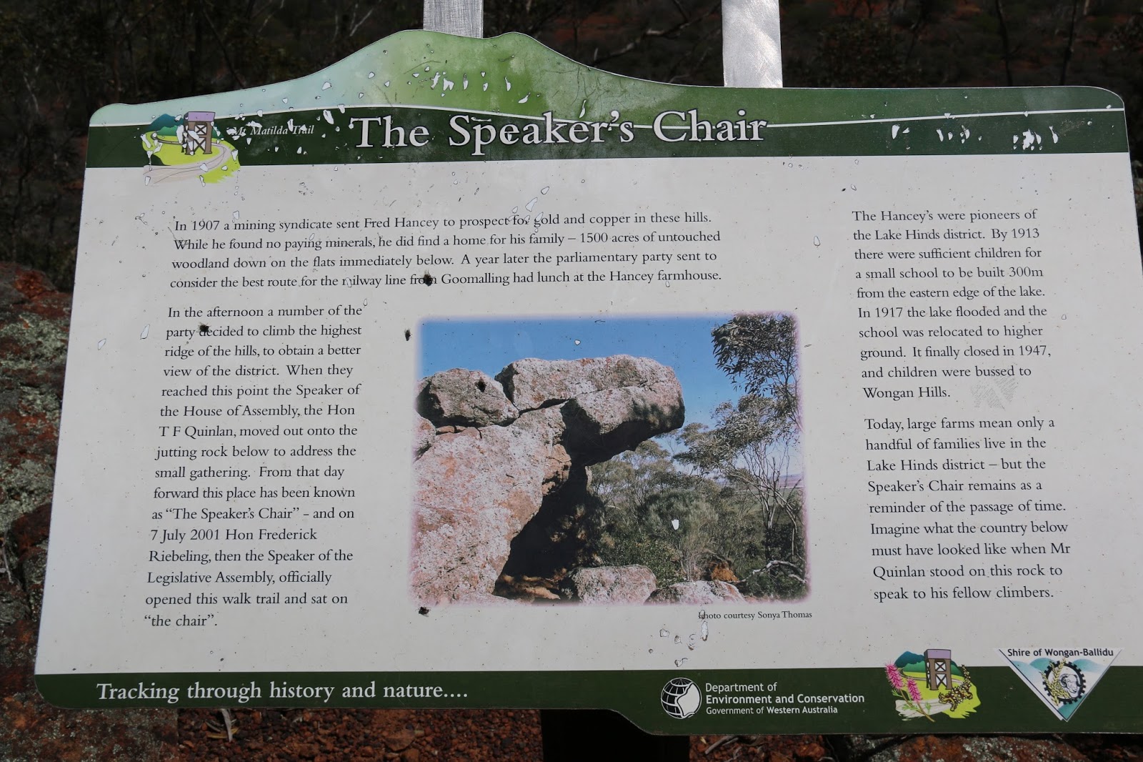
We dove back down the hill and across the saddle to the northern section of the hills which includes a bush walk to the Speakers Chair via Mt Matilda, the highest point in the hills. The Speakers Chair is at the northern tip of the hills and involves a seven kilometre circular walk over the top Mt Matilda, which is a gentle rise, through the bush. It is well worth the walk as many flowers can be seen and there are some impressive views to be had from various lookouts. There not many birds and fewer animals. In 1907 a small party, including the Speaker from the parliament of the day, was at a rock outcrop surveying the countryside with the view to selecting a course for the proposed railway. The outcrop has since been know as "The Speakers Chair" in recognition of the day.
img-2442 is taken from a prominent spot not long after the commencement of the walk looking south and back down the track towards the scenic lookout on Mount O'Brien in the distance.
We were fortunate to see a Thorny dragon sunning itself on the track. Thorny devils ( I know them as devils) have the knack of adopting the colour of their surroundings and are difficult to see. I can count on one hand the devils I have seen in natural surroundings. I can recall seeing a grey devil on granite, a red and yellow devil on red sand and now a brown devil on laterite. Bonnie was fascinated in seeing, for her, a new creature. Bonnie walked about half the journey and the other half she spent sitting on my shoulder. It was hot and a hard walk for a little puppy-dog.She drank nearly a bottle of water.
img-2443
img-2445
img-2447 Gimlet
img-2449
img-2451
img-2452
img-2454 Casuarina female flower and seed
img-2456 Casuarina male pollen
img-2457 Lateritic Break-a-way
img-2459
img-2463 Thorny Devil
img-2464
Thorny Devil
Most creatures, including birds, show little or no fear of Bonnie. She is not in the slightest bit aggressive towards her fellow creatures.
img-2466
Bonnie + Thorny Devil
This Malleefowl nest didn't appear to have been used for many a year as there was no vegetation at all in the mound, apart from windfall leaves.
img-2468 Malleefowl Nest
Internet Pic Malleefowl

img-2469
Large Mallee (Eucalyptus salubris- Gimlet)
This is one tree as all the stems originate from one huge Mallee Root.
img-2470
Large Mallee
Mallee roots were a source of firewood in the early days of farming. Huge mallee root piles were to be seen on all farms once but sadly are not so plentiful these days.
img-2472
Lake Hinds
img-2474
Mallee
img-2475
Laterite Break-a-Way
img-2476
img-2480
Paperbarks
An unusual site for paperbarks to be growing. On laterite on top of a range of hills. A sign nearby suggests that there is a particularly wet micro-climate on top of the mount on the edge of the break-a-way.
img-2481
Lake Hinds
Lake Hinds rarely fills with water and is usually a dry salt lake. Kondut Flats drains in to Lake Hinds, when it flows, and the lake overflows (rarely) in to the Mortlock River. The Mortlock in-turn drains in to the Avon River in Northam which is the Swan River by the time it reaches Midland Junction.
img-2489
img-2487
Termite Mound on laterite
img-2485
The Track + Gimlet
This is the top of Mount Matilda. The first Surveyor General of Western Australia, John Septimus Roe, visited this spot in 1936 and erected a stone cairn (an educated guess on my part that JR erected it). Stone cairns were erected by early explorers, especially surveyors, on the top of many hills and are usually about eight to ten feet high. This one has been leveled to the ground to protect YOU from falling rocks. Bloody idiot do-gooders. I chose not to take a photo of the wanton destruction! In another site, that I forget the location, the rocks have been cemented together. Another wanton destruction of our history in the name of safety. Bloody idiotic idiots auta be drawn and quartered.
img2484
Laterite
In many years to come the bauxite miners will be sniffing around these hills. There is no viable bauxite here, given today's plentiful supply through out the World, but in years to come the hills may-well be mined. I saw plenty of signs of reasonable grades of bauxite, but not on the break-a-ways.
img-2491
The Speakers Chair
img-2493
Speakers Chair.
The current speaker regularly lectures me!
img-2495
Land settled and cleared in 1907
Lake Hinds in the background
img-2497
Break-a-Way below Speakers Chair
img-2500
Speakers Chair
img-2502
img2503
Bonnie's preferred mode of travel,although she is usually on my shoulder.
img-2505
img-2510
Break-a-Ways
img-2513
The Track
img-2517
Break-a-Ways
img-2518
Break-a-Ways
img-2522.1
Unidentified juvenile bird
img-2524
Unidentified Mum
img-2527
img-2531
Lake Hinds
img-2533
Mt Matilda from Lake Hinds
Oct 19th, Evening. Lake Ninan is 9kms south west of Wongan Hills on the Wongan Hills Calingiri Road and is or was used for skiing in years gone by. Like the gnamma hole at Dingo Rock and the cairn on top of Mt Matilda are dangerous sites then so is the lake as skiing is no longer allowed due to the risk of injury to YOU. Where our caravan is parked used to be the site of the Lake Ninan Yacht Club club-house. Vandals destroyed the building some years ago and the Shire demolished it as skiing is now prohibited. I visited the club-house many years ago after it was vandalized. The trees have been planted.
img-2535
Campsite at Lake Ninan
img-2537
Lake Ninan
Kondut Salt Flats flow in to Lake Hinds and then via the Mortlock River in to Lake Ninan, on rare occasions. The water in this lake is reputed to be six times saltier than the ocean! Most of the time it is a dry salt lake. The Mortlock is nothing more than a string of,usually dry, salt lakes connected by wide salt flats. Another ancient river bed, the Mortlock never really looks much like a river, anywhere along its length, until the last couple of miles through Northam and even then its a creek.
Travelogue 2015/2 Wongan Hills #15.........Ends.........


 img-2541 Eucalyptus macrocarpa
 img-2545 Eucalyptus macrocarpa
 img-2547 Eucalyptus macrocarpa
 img-2551 Eucalyptus macrocarpa
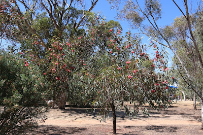 img-2561 Eucalyptus torquata


 img-2632 York
 img-2635 Burgess Siding School
 img-2637 Burgess Siding School
 img-2640 Burgess Siding Teachers Home
 img-2644 The view from the school
 img-2647 LBB
 img-2657 Red-capped Robin


