Travelogue 2015/2 Pindar Beringarra Road
#3

Wild Canadian Goose
an internet pic


 img-0731 Papilio demoleus. Chequered Swallow Tail

Birds of Ballinyoo Bridge Murchison River, thousands of em, (well hundreds if not dozens) later.

November 14th, 2015.
Tonight we are going/have gone to a concert
at Sandalford Wines.
Swan Valley.

G’day,
Pindar Beringarra Road is a minor back road some 350 kilometres long that runs from Pindar to Mt Gould. Six cattle stations can be found along the road, including Beringarra Station. The road terminates at the historic Mt Gould aboriginal lock-up which has been restored. Nothing else can be found at Mt Gould, it only ever was a lock-up. At Yuin Station the road crosses the Greenough River. The Greenough is a minor river of some 200 kms (straight line) in length with half running through Mulga country and half through wheatbelt land. Near the coast the river runs through rich wheatbelt lands known as the Greenough Flats (famous, among other things, as the area where trees grow horizontal) and was first settled in 1851. There is a historical village at Greenough that is worth a visit and is on my agenda for our next trip north. (I digress!)

We travelled some 97 kms of the Beringarra Road before turning north west and headed the 55 kms to Twin Peaks Station. This second section, connecting Twin Peaks and Yuin Stations is a poorly maintained (public) backwater gravel road used mainly by station employees and is definitely not suitable for the average yobbo towing a caravan or for the average tourist in a car for that matter. The 150 odd kms provided a wealth of colour and some interesting scenery along most of the route. The bush was ablaze with everlastings as well as many bushes in flower. Unfortunately Green Mulla Mulla grows as a monoculture growth in places to the detriment of all other ground hugging annuals. Although most Mulla Mulla is an attractive plant I find the Green variety depressing and unattractive probably because in places it has taken over much like a feral weed. In places in the northern wheatbelt it has taken over along the road verges to the exclusion of the very colourful everlastings. Along the Twin Peaks section of the road we stopped for lunch at a very scenic break-a-way which also provided a number hardy species of plants, in flower, growing seemingly straight out of bare rock.
I might ask here for a bit of feed-back please. Although I enjoy writing my Travelogues it is proving to be a difficult task selecting photos. With so many to choose from it is difficult knowing how many to include because I could include far more good pics. The previous blog had 40 pics of flowers.
Question: Is the number of photos about right, too many or add more? Or maybe turn the computer off and go to the pub instead?
Below is a picture of the site of a once busy crossroad pub come provisions store called Bumbinyoo Flats. An unlikely site to build a community but an all important spring providing the only water here-a-bouts was locate here. My guess is the store come pub was probably nothing more than a structure built using Mulga saplings and lined with hessian or possibly, but unlikely, wattle daub, white washed on the inside maybe, and roofed with corrugated iron. It was once the junction of the Geraldton Cue coach road and the Pindar Murchison route. The east west road has ceased to exist, the nearby spring has dried up and there is no sign that people once lived here. The store/pub was run by a Mr Sievwright. We know his descendant who owns Glen Station north west of Cue. I have spent time exploring the remnants of the coach road further east. It hasn't been used for over a hundred years but bits of it can be followed where the coach wheels have left ruts gouged in to the hard surface.


Tonight we are going/have gone to a concert
at Sandalford Wines.
Swan Valley.

G’day,
Pindar Beringarra Road is a minor back road some 350 kilometres long that runs from Pindar to Mt Gould. Six cattle stations can be found along the road, including Beringarra Station. The road terminates at the historic Mt Gould aboriginal lock-up which has been restored. Nothing else can be found at Mt Gould, it only ever was a lock-up. At Yuin Station the road crosses the Greenough River. The Greenough is a minor river of some 200 kms (straight line) in length with half running through Mulga country and half through wheatbelt land. Near the coast the river runs through rich wheatbelt lands known as the Greenough Flats (famous, among other things, as the area where trees grow horizontal) and was first settled in 1851. There is a historical village at Greenough that is worth a visit and is on my agenda for our next trip north. (I digress!)

img borrowed from the internet.
I might ask here for a bit of feed-back please. Although I enjoy writing my Travelogues it is proving to be a difficult task selecting photos. With so many to choose from it is difficult knowing how many to include because I could include far more good pics. The previous blog had 40 pics of flowers.
Question: Is the number of photos about right, too many or add more? Or maybe turn the computer off and go to the pub instead?
Below is a picture of the site of a once busy crossroad pub come provisions store called Bumbinyoo Flats. An unlikely site to build a community but an all important spring providing the only water here-a-bouts was locate here. My guess is the store come pub was probably nothing more than a structure built using Mulga saplings and lined with hessian or possibly, but unlikely, wattle daub, white washed on the inside maybe, and roofed with corrugated iron. It was once the junction of the Geraldton Cue coach road and the Pindar Murchison route. The east west road has ceased to exist, the nearby spring has dried up and there is no sign that people once lived here. The store/pub was run by a Mr Sievwright. We know his descendant who owns Glen Station north west of Cue. I have spent time exploring the remnants of the coach road further east. It hasn't been used for over a hundred years but bits of it can be followed where the coach wheels have left ruts gouged in to the hard surface.

img-0629 Bambinyoo Flats

My apologies to Jolliffe

img-0631 Everlastings

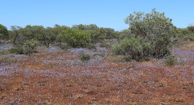
img-0632 Massed flowers

img-0633 Everlastings

img-0635 Grasshopper

img-0637 Velleia

img-0639 Miniritchie. an Acacia
If you can expand these pictures then do so for 0639 and have a look at the bark in the reddish areas. The bark looks as if it has been put through a cheese shredder. This effect is typical of all Miniritchie species.
img-0640 Olearia humilis

img-0641 Burnonia australis + Mulga

img-0643

img-0645

img-0648 Rhodanthe

img-0650 Rhodanthe + Wild Hops
The pretty pink flowers in these two pics are Acetosa vesicaria or Wild Hops. It is a feral weed introduced by Afghan camileers and it has spread far and wide across Outback Australia. The pity is that unscrupulous mining companies further spread the weed by using the seeds as part of their seed mix in re-rehabilitating old mine sites and waste stock piles. It will be the only feral weed I knowingly include in my Blogs.

img-0653 Wild Hops

img-0651 Greenough River + Casuarinas

img- 0654 Mulga

img-0657 Stylidium

img-0662 Break-a-Ways
 img-0663 A natural Bonsai
 img-664 A natural Bonsai
 img-0666 Break-a-Ways
 img-0668 Dodonaea viscosa. Native Hops


img-0669 Dodonaea viscosa. Native Hops

img-0671 Break-a-Ways

img-0673 Mulga
This is typical Mulga country above a break-a-way. There is little in the way of top soil with many plants seemingly growing straight out of rock, with some growing in to miniature or bonsai forms. The dark green plant with a trunk, in the left centre foreground, has an interesting name and that is Dead Finish. It's botanical name is Acacia Tetragonphylla. Cuddingwarra, a long abandoned gold-mining town west of Cue, was originally called Dead Finish presumably due to the number of said named bushes growing in the area. The bush has the unusual name in recognition of the belief that in an extreme drought it is the last species to die.

img-0675 Solanum orbiculatum. Cattle Bush
Also known as Wild Tomato. Some Solanum fruits although bitter are edible but others are highly toxic. I happily eat a number of items from the bush tucker larder but bush tomatoes is not one of them even though Rosalie has encouraged me to try them on occasion.

img-0677 Granite Boulders

img-0678 Caladonia

img-0679 Caladonia

img-0681 Grasshopper

img-0682 Hemiandra

img-0683 Stylidium

img-0685

img-0687 Grevillia eriostachya. Honey Grevillia

img-0690 Grevillia eriostachya. Honey Grevillia

img-0692 Atriplex holocarpa+ Samphire flat

img-0695 Disphyma crassifolium. Round Leaf Pigface
All of this plant can be eaten including the flowers. The succulent leaves are useful in an emergency as a source of drinking water

img-0696 Bluebush + Acacia

img-0703 Eremophila platycalyx

img-0705 Calandrinia ptychosperma

img-0706 Mairena

img-0718 Ptilotus exaltus. Pink Mulla Mulla

img-0719 Ptilotus macrocephalus. Green Mulla Mulla

img-0727 Eremophila laanni
Murchison River Poverty Bush
Murchison River Poverty Bush

img-0730 Papilio demoleus. Chequered Swallow Tail


img-0734 Diporiphora. Two-line Dragon
Travelogue 2015/2 Pindar Beringarra Road Ends
Next travelogue and we will jump forward in time and travel along the New Forest Road to Kalbarri via Northampton and view some of the spectacular bushes in flower and a few birds as well as some spectacular scenery.Birds of Ballinyoo Bridge Murchison River, thousands of em, (well hundreds if not dozens) later.
A sample below

img-1068 Crimson Chat
Geoff

mmmmmm
Hi Just found your blog, thanks for all the wonderful informtion. Love the photos in our opinion the amount is perfect. We are going to do Butchers track, Mount Augustus in spring 2017. Safe travels where ever you are. Kathy and Tim.
ReplyDelete